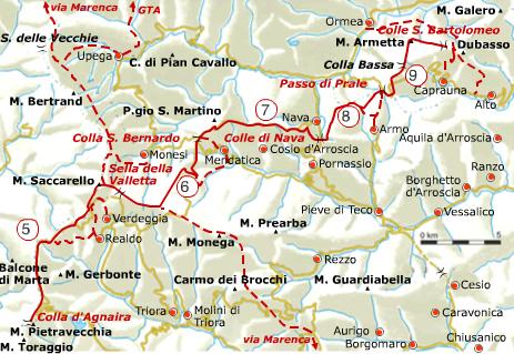
The Alta Via dei Monti Liguri trail is divided into 8 homogeneous geographical areas; after introducing the first westernmost area, the Nervia Valley, here below is the second area: the Ligurian Alps.
The trail runs through thick coniferous woodland and extensive mountain meadowland, where, at the end of spring, vast expanses of rhododendron bloom, conferring to the mountain pastures the typical aspect of a North European heath.
Once entered into the heart of the Parco delle Alpi Liguri (established by Regional Law 34/07), the summit of Monte Saccarello (2.201 m) can be reached, from which we can enjoy a spectacular view embracing the sea and mountains.
On its lesser eastern summit, at 2.166 m, stands the imposing cast iron statue of the Redeemer. Beneath the massif lay the ancient “brigaschi” villages of Realdo and Verdeggia, evidence of the historical and cultural complexity of this spot in Liguria.
The uncontaminated environment and the expanse of the territory have favoured, thanks also to the proximity of the Tanarello Valley, the conservation of Alpine fauna (white hare, chamois, pine marten, marmot) and a wide variety of bird species.
In the surroundings of Colle di Nava (934 m) we find the first Savoy fortifications built in strategic points in order to defend the Kingdom of Sardinia.
The Alta Via dei Monti Liguri is run and maintained by the Alta Via dei Monti Liguri Association, whose members are among those who originally promoted its creation and safeguarding.
For more information:http://www.altaviadeimontiliguri.it
Thanks to: Associazione Alta Via dei Monti Liguri