Highlights
Departure / arrival point: Viola Gradient: 300 m
Time required: 1 h
Degree of difficulty: challenging, both due to its length and gradient. Access:
• from Turin: A6 motorway, exit Niella Tanaro. Proceed along the SP 60 in the direction of Prata and take the SP 28 to Mombasiglio. Proceed along the SP 34 road that leads to Viola.
• From Cuneo: take the SP 564 del Monregalese road and enter the A6 motorway in Mondovì. Exit at Niella Tanaro and follow like above.

Description
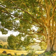
The starting point of this route is indicated near the chapel of St. Caterina (in via Crivella). Take the dirt track on your right and proceed into the woo- dland. Go past the Crivella stream and after about 1.8 km, you get onto a forest path and you continue climbing the north-eastern slope of Piano Stope (1738 m). On reaching the zone known as “Acquafredda”, the route branches off to the south, it skirts the peak of Bric Muceretti and reaches the eastern ridge of the same, also providing a formidable scenic view (at a height of 1560 m, which is the maxi- mum altitude reached in the present itinerary): you will have a magnificent view of Bric del Prato Rotondo and to the south, on the horizon you can see the Bric Mindino peak, with its cha- racteristic cross.
Proceeding towards the valley you go past a building used by the “Margari” (local shepherds) and go past the Mongia stream. Just ahead of the brid- ge there is a famous spring. Following the cart road you come to the Prato Rotondo pass, which branches off into various directions: it is necessary to proceed north in the direction of the woodland. You will skirt the Mongia for a few hundred centimetres, then the path turns in a north-eastern direction and climbs slightly.
After passing a rocky spur the path begins to descend in an easterly direction. Ignore the first uphill turning on the right and turn left a little further on: at the end of the short downhill descent you will see an aqueduct collection tank.
Proceed walking under the water storage tank, keeping to the left of the Farinasso stream. A further ten minutes, and you will reach the Mongia river bed, cross it and then proceed in a nor- thward direction on a dirt road. You will skirt a drying shed on your left and come out onto a clearing of beaten earth. There is a signpost indicating a naturalist route that takes you to the Rocca dei Corvi, along the path you will see a series of explanatory panels pro- viding details of the trees and minerals present in the area.
You will descend into dense woodland, until you reach a clearing where a white boulder offers a wonderful panoramic view over the valley and the Rocca dei Corvi which rises from the stream water. Proceed downhill and when the path enters a cart road, in the vicinity of a hairpin bend, proceed to the right and return onto the asphalt road of Crivella, near St. Caterina chapel.
However we advise you to make a short detour continuing into the woodland on the left. You will thereby reach a clearing where you can see the remains of an old coal bunker. The path leading towards the valley reaches the Mongia river bed, from where it is possible to see a series of small lakes, waterfalls and the imposing Rocca dei Corvi. This is the start of a Via Ferrata (fixed rope route), accessible only if you are provided with sling, helmet and crampon (equipment which may, if necessary, be hired from the Bar Sporting in Viola S. Giorgio) and which links up with the path further up.
Source: ATL Cuneo