The medieval village of Rocchetta Nervina lies on the slope of Mount Terca, on the confluence of the Rio Oggia with the Barbaira stream, in the Val Nervia. The town is located just 13 km from the coast, behind Ventimiglia. This favors the climate, with temperatures almost constant throughout the year on late spring values. Its territory is a crossroads between the Alta Via dei Monti Liguri and the Balcony path, connecting Sanremo with the French cities of Nice and Menton.
The village itinerary
A splendid Roman humpback bridge leads into the ancient village crossed by a network of partly covered streets, the typical "carugi". The carugi are narrow and shady lanes sometimes called also " vico". Immediately there is the oratory of the S. Annunziata which houses two splendid wooden statues of the Madonna and two seventeenth-century paintings representing the intervention of the Virgin who extinguishes the flames, during the attempt by Corsican and Ventimigliesi troops to conquer the village. The oratory rose precisely to thank the miracle. A few steps between the ancient houses and you reach the Parish Church of S. Stefano Protomartire, the real heart of the town. Founded in the 16th century, but with subsequent interventions in Baroque style, the church stands on the most characteristic square of Rocchetta where, during the Christmas period, the typical Christmas fire burns from the night of December 24th to the morning of January 6th. The northern facade of the church overlooks the Piazza del Balun, an ancient fist ball game that has always been practiced by rocchettini. The whole village is a succession of narrow streets and squares that open glimpses and extraordinary views of the crystalline waters of the streams. A nice view can be enjoyed from the pedestrian path under the fortified houses close to the Barbaira stream where it is also possible to stop for a picnic. Already a few steps from the village, the streams are crossed by several small stone humpback bridges, that allow you to make short excursions immersed in nature. Just outside the village there are the characteristic country churches: Sant'Antonio, San Bernardo, San Bartolomeo and Santa Lucia.
The lakes
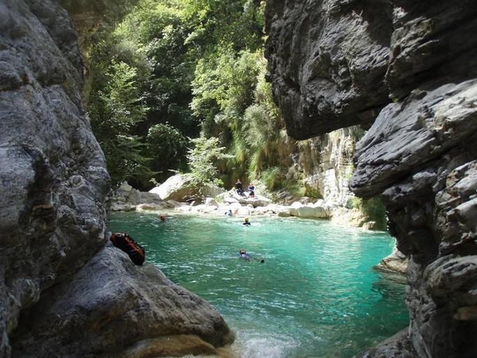
A series of basins known as "the ponds" begins right next to the houses, a summer destination for hundreds of nature lovers. The clear and crystalline waters that reflect the blue of the sky and the bright green of the surrounding vegetation make the atmosphere wild and evocative. Further upstream is the real canyon of the Barbaira torrent where thousands of sportsmen from all over Europe practice canyoning every year. This sport, which assembles the techniques of speleological descent with mountaineering and swimming, is a great attraction and allows to know an absolutely unique environment which is the ecosystem of the canyon of Barbaira, with its rocks, mosses, ferns and its emerald basins. The path (which is part of the Balcony path) to reach the start point of the canyon, begins at the Oratory and passes next to the small country church of S. Bernardo and leads, with a splendid fifty-minute walk, to Ponte Cin and further to Ponte Pau.
Paths on foot and by bike
- Fontanaviva Path
- Isolabona Path
- Altavia and old Downhill Path
- Marcora Path
- Pigna and Airole via Altavia Route, Cin and further on to Ponte Pau.
Caves
In Rocchetta Nervina there are caves and rock cavities, which preserve fantastic legends of witches and magic healers. To reach the caves it is necessary to be accompanied by competent and qualified people who can guide you to discover these evocative caves. For info and visits, contact the Speleo Group of Cai di Bordighera at the telephone number (+39) 328 123 7029.
- Strassasacchi Cave - Rio Coe
Altitude 560 meters, 600 meters development. It is excavated in nummulitic limestone with a sub-horizontal trend, and with a mainly phreatic morphology. It presents grandiose, very sloping environments and bottlenecks that hinder its exploration.
- Abisso Sgora - Location Paú
Altitude 920 meters, development 382 meters, depth 83 meters. Tectonic cavity, shows impressive phenomena of collapse especially in the terminal part of the cave; a new branch was explored by the Speleo Club of Sanremo in 1993.


