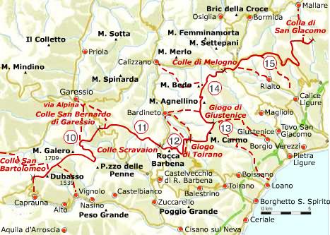
The Alta Via dei Monti Liguri trail is divided into 8 homogeneous geographical areas; after introducing the first westernmost area, the Nervia Valley and the second area: the Ligurian Alps. here below is the third area: Melogno
Monte Galero (1.704 m), Rocca Barbena (1.140 m) and Monte Carmo di Loano (1.389 m) are the reliefs which most characterise this tract of the trail. Spectacular conglomerate sculptures called “the Rock Giants” stand out clearly against the sky near the summit of Monte Galero, while from the top of the mountain we can enjoy fascinating views on the Tanaro and the Pennavaira Valley below.
More towards the East, other monolithic sculptures give shape to the steep and fascinating Rocca Barbena. Environments with microclimatic features very different one from one another confer to this territory a considerable botanical interest, with typical northern species such as blueberry, dwarf juniper and rhododendron.
Beyond Monte Carmo we enter the Beech Forest of Melogno which has represented, over the centuries, an inestimable resource for the local population. In the Forest, considerable for its vastness and quality there are, besides: birch, silver fir, ash and sycamore.
For more information:http://www.altaviadeimontiliguri.it
Thanks to: Associazione Alta Via dei Monti Liguri


: with snowshoes to discover little villages and breath-taking views")

![Hanbury Gardens, itineraries for everyone all year round [Videos]](https://www.italyrivieralps.com/typo3temp/pics/g_a7708c6a79.jpg "Hanbury Gardens, itineraries for everyone all year round [Videos]")